Introduction
New York Subway system is one of the most intricate systems in the world. Here is an attempt to understand it through the lens of Manhattan Avenues and Streets.
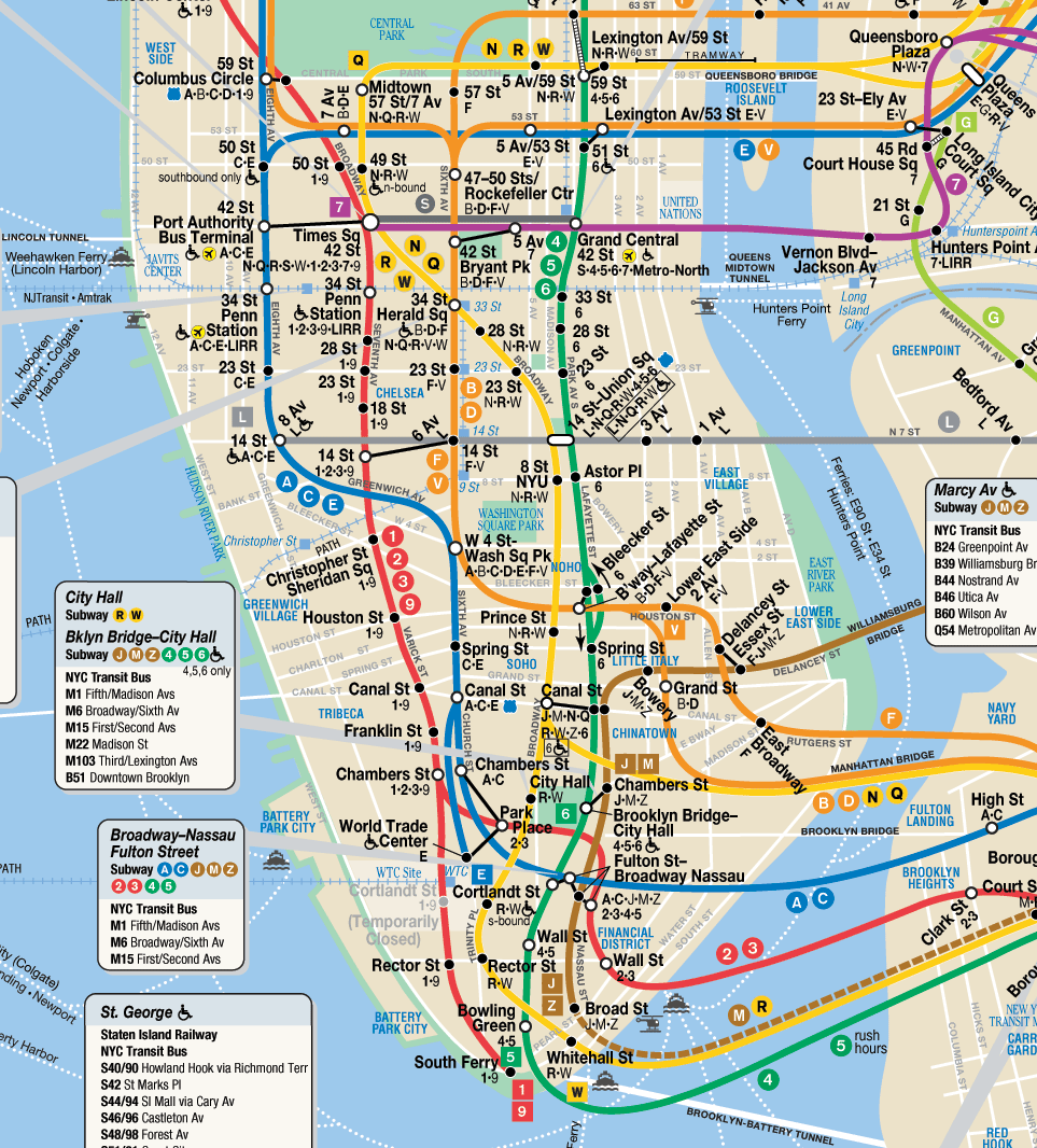
Avenues
Central Avenues
| Avenue Name | Location | Description | Notable Landmarks | Subway Lines |
|---|---|---|---|---|
| Broadway | Diagonal from Bowling Green to Inwood | Cuts through the grid, Manhattan’s most famous avenue. | Times Square, Flatiron Building | 1, 2, 3, N, Q, R, W |
| 5th Avenue | Central dividing avenue | Defines East/West numbering; luxury shopping corridor. | Empire State Building, Central Park | Closest subway: 6, N, R |
| Park Avenue | East Side (Union Square to Harlem) | Affluent area with luxury buildings. | Grand Central Terminal, Park Avenue Viaduct | 4, 5, 6 |
| Madison Avenue | Between 5th Ave and Park Ave | Known for luxury boutiques and the advertising industry. | Madison Square Park | Closest subway: 6 |
| Lexington Avenue | East Side, parallel to Park Ave | Major commercial and residential corridor. | Chrysler Building | 4, 5, 6 |
West Side Avenues
| Avenue Name | Location | Description | Notable Landmarks | Subway Lines |
|---|---|---|---|---|
| Central Park West | West of Central Park | Scenic residential area along Central Park’s western edge. | American Museum of Natural History | A, C, B, D |
| Columbus Avenue | Continuation of 9th Avenue (Uptown) | Runs through the Upper West Side. | Lincoln Center | 1 |
| Amsterdam Avenue | Continuation of 10th Avenue (Uptown) | Primarily residential and commercial. | Cathedral of St. John the Divine | 1 |
| West End Avenue | Continuation of 11th Avenue (Uptown) | Quiet residential area near the Hudson River. | Riverside Park | No direct subway lines |
| Riverside Drive | Westernmost residential avenue | Scenic drive along the Hudson River. | Grant’s Tomb, Riverside Park | Closest: 1 (Broadway) |
| 12th Avenue | West Side Highway | Highway-like avenue, industrial in parts. | Hudson River Greenway | No subway lines |
East Side Avenues
| Avenue Name | Location | Description | Notable Landmarks | Subway Lines |
|---|---|---|---|---|
| 1st Avenue | Easternmost main avenue | Major residential and commercial street. | United Nations | Closest: 4, 5, 6 |
| 2nd Avenue | Parallel to 1st Avenue | Residential and commercial, with the Second Avenue Subway. | Sutton Place | Q |
| 3rd Avenue | Parallel to 2nd Avenue | Popular shopping and dining corridor. | Murray Hill, Kips Bay | 4, 5, 6 |
| FDR Drive | East River (highway-like) | Runs along the East River, primarily for car traffic. | East River Greenway | No subway lines |
| Pleasant Avenue | East Harlem | Short, residential street with Italian-American heritage. | East Harlem | Closest: 6 |
Alphabet City Avenues
| Avenue Name | Location | Description | Notable Landmarks | Subway Lines |
|---|---|---|---|---|
| Avenue A | Alphabet City | Runs parallel to 1st Avenue. | Tompkins Square Park | Closest: L |
| Avenue B | Alphabet City | Residential and community-oriented. | Community gardens | Closest: L |
| Avenue C | Alphabet City | Further east than Avenue B; residential and commercial. | East River Park | Closest: L |
| Avenue D | Alphabet City | Easternmost avenue in Alphabet City. | Community-focused | Closest: L |
Special or Diagonal Avenues
| Avenue Name | Location | Description | Notable Landmarks | Subway Lines |
|---|---|---|---|---|
| Broadway | Diagonal from Bowling Green to Inwood | Cuts through the grid, Manhattan’s most famous avenue. | Times Square, Broadway Theaters | 1, 2, 3, N, Q, R, W |
| The Bowery | Diagonal from Chinatown to East Village | Historical street with modern cultural significance. | Bowery Ballroom | J, Z, 6 |
| Allen Street | Lower East Side | Connects the East Village and Lower East Side. | F, M | F, M |
| St. Nicholas Avenue | Harlem and Washington Heights | Runs diagonally through northern Manhattan. | Historical landmarks in Harlem | A, B, C, D |
| Edgecombe Avenue | Harlem and Washington Heights | Runs along Highbridge Park, primarily residential. | Highbridge Park | Closest: C, 1 |
Streets
Downtown Streets
| Street Name | Subway Lines | Location | Key Features | Notable Landmarks |
|---|---|---|---|---|
| Wall Street | 2, 3, 4, 5 | Financial District | Major financial hub of NYC. | New York Stock Exchange, Trinity Church |
| Fulton Street | A, C, J, Z, 2, 3, 4, 5 | Financial District to Lower Manhattan | Connects key subway lines in Downtown Manhattan. | Fulton Center, World Trade Center |
| Canal Street | N, Q, R, W, J, Z, 6 | Chinatown | Major commercial street, hub for Chinatown and SoHo. | Manhattan Bridge entrance |
Midtown Streets
| Street Name | Subway Lines | Location | Key Features | Notable Landmarks |
|---|---|---|---|---|
| 42nd Street | 1, 2, 3, 4, 5, 6, 7, A, C, E, N, Q, R, W | Midtown | One of NYC’s busiest streets, connecting east and west sides. | Grand Central Terminal, Times Square |
| 34th Street | 1, 2, 3, B, D, F, M, N, Q, R, W | Midtown | Major shopping and transit corridor. | Penn Station, Herald Square |
| 14th Street | 1, 2, 3, F, M, L, A, C, E | West Village to Union Square | Connects west to east, major transit hubs. | Union Square, Chelsea Market |
Uptown Streets
| Street Name | Subway Lines | Location | Key Features | Notable Landmarks |
|---|---|---|---|---|
| 125th Street | 1, 2, 3, A, B, C, D, 4, 5, 6 | Harlem | Main commercial street of Harlem. | Apollo Theater, Harlem Markets |
| 145th Street | A, B, C, D, 1, 3 | Harlem | Serves as a central transit hub for upper Harlem. | Jackie Robinson Park |
Special/Diagonal Streets
| Street Name | Subway Lines | Location | Key Features | Notable Landmarks |
|---|---|---|---|---|
| Houston Street | 1, 2, 3, A, C, E | Lower Manhattan | Divides SoHo and Greenwich Village. | Katz’s Delicatessen, SoHo shopping |
| Delancey Street | F, M, J, Z | Lower East Side | Major connector between Williamsburg Bridge and Manhattan. | Essex Market, Williamsburg Bridge |